Origin of the name:
The name derives from the ancient people that
lived in the region: the Sardinians. Colonized by Fenici, then from Greek, it
was from these last call Ienusa, because in its geographical form it seemed the
form of a human foot.
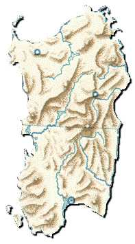
| Reliefs - Passes - Coasts -
Islands: |
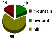
| The mountainous territory is constituted
to north from Limbara Mountains, while in the central oriental zone rises the
thick of Mountains of Gennargentu, whose peak more tall it is that of Punta La
Marmora. Disconnected toward west there are Mountains of Alà, of Goceano, of
Marghine and other brief chains. In the southern part of the island there are
Mountains of Iglesiente and Sulcis where of the lead mines and zinc are there.
The mountain tallest of this chain are Linas Mountain and Caravius. In the part
northerner and Oriental the coasts are rocky, while in the part westerner and
Southerner the coasts are low and sandy and partly marshy. Departing from north
and moving each other from Punta Falcone up to Capo Comino the coast is very
jagged and rich of inlets with some small bays.
|
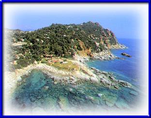
Splendid tourist zone of Arbatax
|
Here Gulf of Olbia is found. From Capo Comino to Capo
Carbonare the coast is linear almost all, and it is interrupted only by Gulf of
Orosei.
Between Capo Falconara and Capo Spartivento is opened Gulf of Cagliari. The
whole western coast, from Capo to Capo of Argentiera is very more complex. The
biggest gulf is that of Oristano. The northern coast introduces the tortuous
Gulf of Asinara and the wide inlets, up to Punta Falcone. To the two
extremities of the island we find some small islands that are few distant from
the coast. The principal is: to north Asinara, Maddalena, Caprera, Molara and
Tavolara; to south St. Pietro and Sant'Antiocco of volcanic origin, that it
attached to the dry land for a brief line.
Landscape:
Sardinia is a region with one detail and only
aspect. The panorama that lives these zones can be identified in
Dolomiteses, or, the roads seem those of Spain. A thing is certain: this Region
always has thousand different faces the one from the other. The vegetation is
composed by expanses of grass and stones, from cork oaks, ulivi and palms,
ponds populated by flamingos, thin to cross animals as wild boars and bucks.
The territory is predominantly mountainous and hilly, where wide green valleys
are opened with all more varied tones. The few level areas are surrounded from
the hills. Confined by enormous blocks of rock, long beaches of white and pink
sand appear.
Agriculture - Stock-farm -
Fishing:
The reclamations done to the level coastal
grounds, have allowed of to develop the crops mostly, but the principal problem
always stays the little fertility of the ground, that doesn't allow of to pick
up products in great quantity. The ulivo and the grapevine are cultivated in
the hilly zones. Wheat's production, bowline and vegetables are cultivated in
Plain of Campidano. Notable is the production of beets and oranges. Typical
product of Sardinia is the cork oak, which is favored by the very arid ground.
The breeding of the ovinis exists since the most ancient traditions. Very
prosperous therefore is cheeses' production, meat and wool. The fishing has
never interested the Sardinians since the antiquity. The only developed fishing
is that of the tuna, and of the lobsters. In the coasts eels and mullets are
fished. Very important is the fishing of the coral.
| Industry - Tourism: |
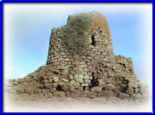
Nuraghe Saint Barbaric
in Macomer in Nuoro
|
Some between the biggest existing
petrochemical complexes in Europe are found in the zone of Porto Torres in
province of Sassari and in the proximities of Cagliari. Modest are the
manufacturing productions of the paper, of the cheeses, of the laminates in
allumino and of the chemical products. Enough developed is the industry that
extract , thanks to zinc's layers, lead and coal that Sardinia is rich of it in
the subsoil. With the construction of the artificial lakes on the rivers Tirso,
Flumendosa and Coghinas the production of the electric energy overcomes the
regional requirement. Some handicraft products still have a some economic
weight.
|
Between these we remember the production of carpets and
wool covers, ceramics, beaten iron and the workmanship of the coral. The
tourism is very developed in the last years especially. The beauties of the
island attract many tourists. The places more frequented are Coast Smeralda,
Bay of Alghero, Gulf of Cagliari and Gallura.
Position and Frontier:
Positioned in the northern part of Mediterranean
Sea, Sardinia has bathed to east from Tyrrhenian Sea and to west of Sea of
Sardinia. To north we find the narrow of Mouths of Bonifacio that it divides it
from Corsica, politically ownership of France. Some smallest islands can be
found to north and south of the island.
Rivers - Lakes:
The rivers of Sardinia are to torrential
character. The principal is Tirso that flows in Gulf of Oristano. Other
important rivers are Coghinas, Flumendosa and Samassi or Flumini Mannu.
Climate:
The climate is mild. In the coastal zones the
winter is lukewarm, while enough rigid on the tallest mountains. The summer
period is warm and dry. The rains are scarce and they are assembled to the
beginning in the spring and the end in the autumn. In the winter period the
island is struck by the wind mistral that is a very violent western wind.
Population:
The population is thickened in the cities and in
the villages, leaving in this way vast desert zones, where the only forms of
life are the shepherds. The only chief town of province that overcomes the two
hundred thousand inhabitants is proper Cagliari. In the times, the illnesses as
the malaria, the hostile attacks of the pirates or other populations, the
Sardinians have pushed to leave the coasts and to advance in the more sheltered
hilly and mountainous zones preferring the pasture to the fishing as form of
maintenance. That's why the Sardinians don't also have a tradition marinara
having the whole bordering region to the sea. The Sardinians have always lived
in their community without possession contacts with other cultures. Only in the
last 50 years the isolation has broken. the traditional uses and the social
conditions have changed. In the coastal inhabited centers where once there were
malarial lowlands, today the most beautiful and famous places bathing
existing rise to the world with some ultramodern tourist fittings.
Communication:
The island is connected to Italy thanks to the
ferries that make head to the harbors of Olbia, Porto Torres, Cagliari and
Sant'Antiocco. The road net is already very efficient, but with the big influx
of tourism and the development of the city, it is widening each other. The
construction of a speedway puts in connection Cagliari-Oristano-Sassari-Porto
Torres and with the secondary nets it also reaches the secondary centers more
insides. The railway net is limited to put in communication the urban centers
more developed: the conformation of the ground hinders the construction of
other lines of it. The most important airports are those of Elmas next to
Cagliari, Fertilia to few kilometers from Alghero and Venafiorita in the
proximities of Olbia.
Web Site designed by
MediaSoft - © Copyright 1998-1999 - All rights reserved